Gridlines: Walking the ST63 Down

Walk — 02/09/2016

A necessary day off work and still energised after my long walk along the GR4 from Montserrat to Sant Vicenç de Castellet, near Barcelona.

In the week run-up to this, I’ve been poring (pawing? pouring? pooring?) over the OS maps on Bing, Open Street Map’s becitizenized paths, and Google’s satellite images. I have a great fondness for walking from the front door. But nothing really ‘took’. The post-industrial, nature-clawing-back of the River Avon to the east is too familiar. To the north, the monotony of the suburbs; to the west: the social housing and barely-functioning industry that so often lines the edges of city centres.

No, I need a concept, something that might give me direction: a move away from the whims of personal intrigue; of willful wandering.

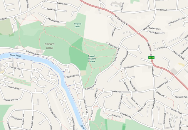
From the OS maps, I notice the gridlines, and we live just shy of the intersection of ST63 and ST73. That’s it: I shall follow one of these lines as closely as I can. But which way? South: it has to be. After less than 1km, I’ll need to cross the Avon, and without a huge diversion, there’s only a single option: the Avon’s oldest ferry crossing to Beese’s Riverside Bar. The bar’s only open during the summer, and so too the ferry crossing. I can follow the gridlines in other directions in the depths of winter.

Ferry. What is a ferry? I grew up landlocked; a brook opposite the house. The nearest big river was the Thames in Oxford, but we rarely went. So a ferry to me is the behemoths that run from Dover to Calais. My first shock at the non-industrial sized ferry was the 20-berth fishing boat taking people from Mallaig to Knoydart, NW Scotland. Until arriving at Mallaig, I could only picture a vast boat, with bars, amusement arcades, and vehicles. A lifetime’s conception dashed, but pleasingly so. Beese’s ferry is even smaller, carrying a maximum of six people.

* * *

So I’ve made it. In about 5 hours I’ve covered eight 1km segments, plus a bit more either end. But that’s as the crow flies (imagine: a crow flying straight!); it’s a fair bit more underfoot: a zigzagging, doubling-back meander. Now, I’m tired, my legs ache, blisters flowering. The bottoms of my jeans are heavy with water because this is not Spain, and there is rain, and there are ticks.

wp_20160902_13_02_00_pro

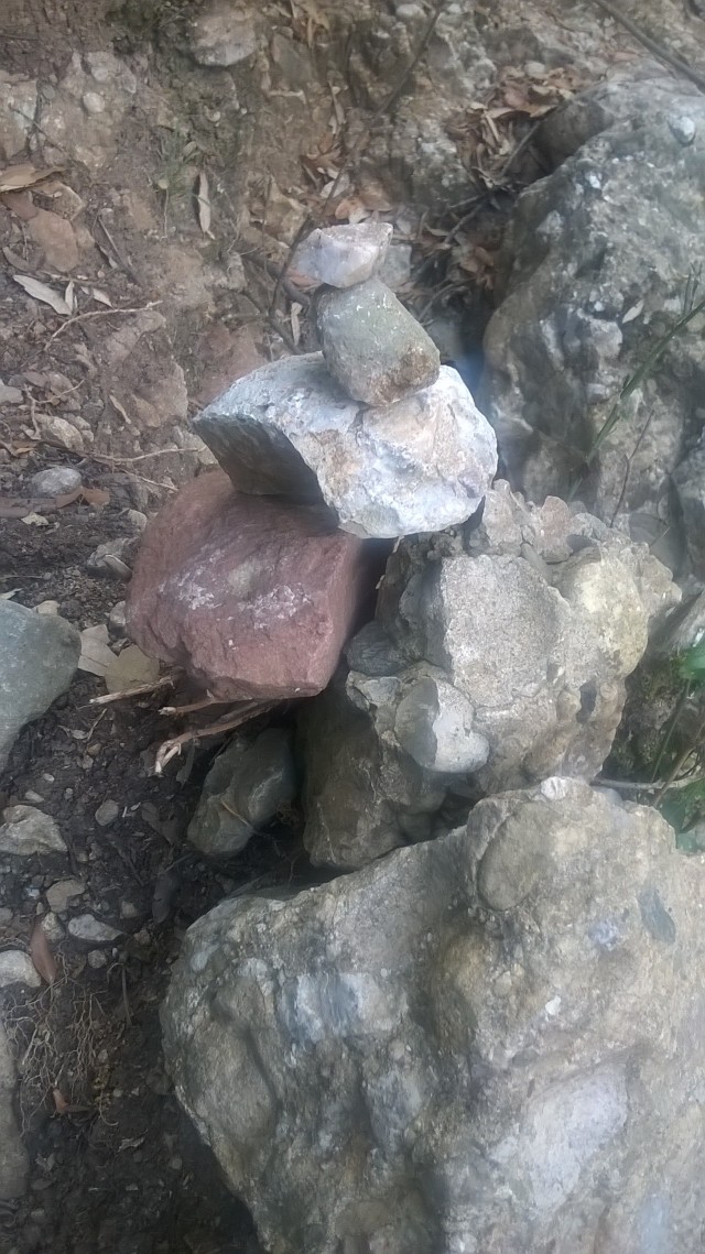
Paint splatter/hunting bittern/limping bull reed.


* * *

Some might like to praise the UK for its plethora of paths, taking in as they do the long distance trail as much as the quotidian and local. I, however, was not praising the quality of the path marking. I was surprised: the closer to the city (Broomhill near Beese’s; Stockwood Open Space Nature Reserve), the less likely the rights of way are to be signposted. I followed wrong paths back on myself; pushed through bramble thickets; raised my hands aloft through head-height stinging nettles — only to have to turn back. I started to rue my straight-jacket decision to follow the fictions of the Ordnance Survey’s Cartesian cross-lines. Wouldn’t it be much nicer to have a walk at a beauty spot? What is this going to prove, anyway?

But I stuck with it. Of course I did.

I have lots of ideas, most of them fleeting, but if I get as far as starting the journey, I’m loathe to abandon. Even the unexpected rain (that went from fairy mist to persisting-it-down), did not tear me from my aim. And so much the better.

It’s peculiar, following the lines. The walk can be categorised into three scenes: 1 — suburban Bristol; 2 — single-track country lanes; 3 — field footpaths. Because I had the schema, I missed most of the villages on the way. I ignored the most intriguing-looking paths. I merely chose the route that allowed me to follow line ST63 most closely.

It took a long time to feel I’d left Bristol and its conurbations. For every leaf-dappled lane, every overgrown path, there followed as much in the way of post-war bungalows and social housing, bus stops and convenience stores. Horseworld was especially confusing  — a sanctuary for diseased horses (according to one sign, feeding the horses is forbidden because they may transfer diseases deadly to humans). Horseworld resolutely threw out the notion of ‘the city’, with its stables, paddocks and electric fences — only for houses to reappear. And why does a city like Bristol require a horse sanctuary?

WP_20160902_16_03_57_Pro.jpg

Mountains of the mind.


* * *

Out of the city proper, and onto the many, many unclassified roads. Some were narrow, steep, and with near-vertical banks to cling to as cars approached. Some were wider, encouraging lead-footed drivers to swerve to avoid me. The most fun on those lanes, was the abuse hurled at me from a small hatchback. Incoherent, but I transcribed to my phone what I heard:

“Awefurfife fur fa fawf!”

Quite.

I grew up in the countryside. Narrow lanes and speeding cars are nothing new to me. On the city’s edge, I imagine gangs of adolescent youths, at the end of long summer holiday, hurling abuse, and possibly worse. I’ve always had this sense; a feeling that arises from the unknown. But despite all this, the country lanes, on this wet day, really got to me. When I heard a car far off I’d tense up. Anxiety would start with a tiny thought before torpedoing down to my heart, where it would bloom into heavy-handed arrhythmia. I started to dread the approach of every car; imagined scenarios where two could cars would need to pass each other right where I stood, pinning me to the bank, speeding off, leaving me. And it was because of this that I broke my rule.

I was near the end of the walk in Pennsford, and the last bus stop before wandering off the map’s edge. The road: steep, narrow. The cars: fast. Legs: sore. I wanted the walk to last longer than it otherwise would (the sore legs a pleasing ache of achievement). I ducked off the road onto some footpaths. I went round the back of a church, which had a barbecue in the graveyard. I looked at the limping sheep, one so poorly it wouldn’t get off its elbow; it’s toenails overgrown, black and gnarled. I zigzagged a river at the path’s whim.

And then, after 5 hours, I was in Pennsford. Its single-cell gaol, the vast railway viaduct, the pubs, cafés and museum, and of course, the bus that arrived just as I did.

Krickrickreck: Strange occurrences on the GR4

Walking the Catalan Pre-Coastal Range – 18/08/2016

Monestir de Montserrat a Sant Vinenç de Castellet

WP_20160818_007

Cable-car to Monestir de Montserrat, and the walk’s start

As soon as I got off the 1.5 hr loops I didn’t see any one. But I heard people: gentle talking on a parallel path above mine. But there was no path. I even heard voices and movement when the cliff to my right was sheer. This was before I got very tired, and up in the cool, high air of the mountain. But I’m convinced it wasn’t my imagination. Utterly. But that doesn’t mean I can explain it. I balanced a small quartz stone on a tiny cairn.

WP_20160818_020

The high path and parallel voices


WP_20160818_022

Add a stone to the cairn


Later, I came to a small monastery. A sign for the GR4 pointed me down an unused-looking path alongside the carpark track. It didn’t seem right, but the arrow looked pretty confident. I got to wooden hut, perhaps a hide. A sign in both Spanish and Catalan seemed to say: don’t proceed further without permission. But it was the only path I could see: steep steps off the steep cliff. I edged slowly forward to try to decipher the status of the steps: whether they were safe, and whether this was my path. I passed the hut and was startled to see a man sitting out and staring to the vast plain below. I was ruffled, but remembered enough to cobble ‘dónde está la gran recorrido quatro?’ He understood. I knew roughly that it went down the valley side, so was surprised when he told me to go back across the main road and rejoin the path I’d left. My puzzlement translated, and he seeked to clarify: Lo siento, GR 4?; si, quatro. Ah! Perdon. He checked his phone and I’d been too hasty with the right turn, and he wasn’t familiar with path. He apologised again and I left to take the proper path down the valley.

* * *

Back onto the path, and again no single other walker (though some mountain bikers and a couple of cars). I was no longer followed by occasional chatter or slipping rocks from a hidden path. Who made those noises before? And who was this man, only too pleased to help a hapless hiker? How, and why, was he there?

WP_20160818_023.jpg

KRiCKRiCKRECK – the walk’s timbre

Saint George, Bristol: Paths, Cuts, and Lanes. PROLOGUE

I have decided to document the paths and lanes around where I live. I live in Saint George, Bristol, or possibly Crews Hole, depending on who writes the address, or which map you look at. Our flat is a few hundred meters from the River Avon, though despite our ellevated vantage point, the river cannot be seen, though its route is clearly visible as it wends its way downstream.

It is, however, just possible to see Crews Hole Road [sic – the lack of apostrophe in ‘Crews’ is not my doing]. We can also just spot the peaked roof of the recently-reopened Bull Inn, just beyond the cliff-clinging Buddleia plants that edges the flats’ carpark.

The aims of this project (at this point of time, leastways) is (1) to document some of the hidden, and not so hidden, routeways of the area; and (2) to learn how to get the most out of my oft-neglected Nikon F65 SLR (film) camera.

So some more detail. First, the paths and lanes. There is quite a variety of walkways roundabouts this steep valley slope. There are the roadways that plummet straight down the hill, the narrow paths cutting between houses and past backs of  gardens. There’s Trooper’s Hill nature reserve with gravel-surfaced paths through the heather, and the tarmac’d River Avon path. Some trails are overgrown and unused, such as the path that starts at the end of our car park, and there are rat-runs through pavement-less narrow lanes, unnerving for walkers who find themselves facing a suped-up Mitsubishi, or impatient van driver.

Second: my camera. I have owned the camera for about 8 years. For a good few years it’s been mothballed, collecting dust in the spare room. I recently got a copy of Natural-Light Photography by Ansel Adams (1952: 1971, Morgan & Morgan: New York) from Bristol Central Library. It’s pretty technical, recommending all sorts of light meters, and discussing the merits and demerits of various, and largely obselete, film types; but depsite that, it is the philosophical approach to natural light photography (a term that refers to not only outdoor shots, but the process of photography that does not use specialist lighting equipment) that is inspiring.

I intend to use a single film per routeway. This means about 36 shots each time – so I will have to think carefully about every photograph. I documented a path today and used about 2-and-a-half films! Using a digital compact camera has certainly made me lazy about photos, with its vast memory and instant results. I look forward to slowing things down, to take my time; and from this, become more attentive of my local area.

There is another aspect to this approach which I hope will be useful. There will always be a lag between photographs taken, and photographs developed (barring converting the spare room into a darkroom). It means it is possible to write some notes about each path during or immediately after, perhaps with some research. But once the photographs are developed, it is hoped I will have a new perspective – perhaps something I missed during the excursion, or that ability to look at something in its fine, static detail.

Essentially, I envisage that the process will embody three key elements:

  1. Close observance and photo-framing during the walk
  2. Writing and considering my thoughts and feelings of that walk
  3. The close study of the returned photographs in all their pristine, and not so pristine, detail.
St George/Crew's Hole

St George/Crew’s Hole area. Click map to got to OSM.

Sun-ways not Widdershins – revisited

On 16th October 2014, I published a post of a walk through the field near work. This week, I took another close look. But this time from the start of the summer.

 * * *

TOWERING TREES

varicose veins | flames of green buds | cumulonimbussing conker tree

* * *

SEVEN HOLED SURFACES


* * *

FLOWERS OF MEADOW & HEDGEROW

unknown with grass | willow grass | lesser stitchwort | nettle: stinging and dead | hawkweed | elderflower

* * *

FRUITS OF SUMMER COMING, SUMMER PASSED

elderberry | blackberry | fig

* * *

CRAWLING

spider nest | honeydew | scorpian fly | cuckoo spit | anthill | humble bumblebee

* * *

EPHEMERA

If Bristol were flooded.


* Video is my recording of a film shown at Millenium Square, Bristol, on 03/05/2015. The original film Cheers, Drive! can be viewed at: http://www.triplegeek.com/portfolio/visuals/cheersdrive.

* Boat images are of the Withdrawn exhibition in Leigh Woods, near Bristol, described as “an unexpected encounter with a flotilla of abandoned fishing boats installed in the depths of the woodland”. More details at: http://www.lukejerram.com/projects/withdrawn

Bendochy – a poem

BENDOCHY

?????????????????????????????????????

cold cold cold
the green man’s face blooming.

bloom of my own, this curse of the Celts:
the tiny red fissures at the surface, closer than
most, like a map of blood-red
wind-felled trees.
the ice wind sucks heat
from these threads, my face
feels like the blood is
being frothed out of my skin then
freezing, holding my features,
a grimace.

middle age abbey, medieval gaol,
Victorian barracks, ancient cross.
manacles on a standing stone:
age unknown, but still
a reminder, of something not
remembered

the wind off the river flows
right to this church, for Bendochy
parish, walls to keep out the
icewind and doubts, a shelter acute
when against savage nature

the green man still grins
the cursed Celt grimaces


This poem first appeared in Wyrd Daze, “the multimedia zine of speculative fiction and experimental music & art”. Reproduced with thanks. Visit Wyrd Daze for more.

Not (yet?) the cove of forgotten dreams

What is this gap, this cut, this cove?

From the river path, I see a trunk sewer, elevated above the ground. Duck under, and a ruined concrete and brick structure. My eyes dance across the surface of broken angles; peer into a rubble-strewn chamber.

But soon, I am looking at something more massive. A cliff, dwarfing the ruin and sewer. (Though is massive the correct term? A cliff suggests a lack of mass, a void. But whatever might be appropriate, it is surely a derivative of ‘very big’). The cliff a horseshoe of wall, and trees sparsely fill the flat bottom and lower flanks.

Up high, leafless and stunted trees tiptoe on the edge of the golden-in-sunlight rocks. It’s sandstone, I think. Or maybe limestone. The lower cliff faces are shiny wet and pattered in sunlight. Here the water seeps through the rock’s crevices, and drips off the brambles and ivy. Not quite a din or cacaphony, but an asyncopated collage.

SAM_2559Drip         Drip                               Drip               Drip                 Drip    Drip                       Drip                     Drip                         Drip                           Drip      Drip                          Drip          Drip               Drip                                  Drip             Drip              Drip        Drip                    Drip               Drip                                        Drip                     Drip  Drip               Drip        Drip  Drip                                      Drip                  Drip     Drip                      Drip                  Drip

I’m at the highest point I can get to from the bottom, and the space is quite a wonder: an amphitheatre of stones and gravel facing a stage empty but for the trees. What happened here? How did this place come to be? I search high up on the cliff faces, looking for prehistoric rock art. A folly practice, in a site near the city in view of the busy river path, but I look all the same.

But there is still rock art – the furze of spray paint. The prescence of modern (that is, contemporary) people, or at least, the signs of their prescence, sometimes unnerves me. I can happily lie in a flimsy bivuoac in the thick night while foxes bark and owls screech, but if the thought that I might be discovered by a gang of kids or a gamekeeper crosses my mind, I’ll not be sleeping. Now, seeing this rock art, the narrowmindness of my romantic prehistoric-focused imagination is thrown in to sharp relief. I wonder: what would an archeologist make of this space in two-thousand years?

In Don Fernando, W. Somerset Maugham considers that great proto-postmodernist tome Don Quixote and the mention of a meal named duelos y quebrantos, which translates as pains and sorrows. He points out the great scholarly exertion used to find out what this dish might be, for it to be discovered that it’s merely bacon and eggs. He then leaves a quip about bubble and squeak, anticipating the three-hundred years of investigation into what this meal could possibly be. And so to here: as well as the spray paint, there’s a picnic bench and abandoned tent, as well as the concrete ruin and sewer pipe. When this place is buried and then excavated, what conclusions would future thinkers draw with regard to this space? Picnic bench as ceremonial table? Tent as nomadic home left in a hurry? Sewer pipe a sign of Romanesque technology?

I scramble back down and it becomes clear that the boulder and scree is not timeless; permanent. There are signs of a recent rockslide. In among this largely plant-free stony debris is a tree with large blocks against its trunk. Other trees lie half buried, their roots rising skyward. Fractures in the rock face portend the next rock fall.

Sun-ways not Widdershins

Tweets from a walk of 10 October 2014. Photos from the same walk, made on 16 October.

From the Height of Midsummer

A wildcamp

The trees all around are of narrow girth, like fenceposts; two hands fit around, but much taller: a beech canopy, half hiding the sky. I find an ancient beech, one of far greater circumference – so large I can lean my bike against the far side and it is hidden from the road. I sit for what feels like hours. I jumped over a fence to get here, aware that a wayward gamekeeper may not appreciate my prescence. The sun’s long set, but still I wait. I’ve not been aware of anyone passing behind, save for one car, and the eerie swoosh of two cyclists.

The middle of the night: I can hear church bells. Not the monotone note marking the passing of another hour; this is a peel. I am deep in a woods but can’t help but look around. I see nothing in the gloom, and certainly not the source of the chimes. But still they ring, on the very edge of my perception. Mischevious campanologists? Midsummer ritual? What else? I drift back to sleep.

I am sitting on a root bole, waiting to feel safe enough to bed down. I look up at the beech’s domed canopy. Dusk was long ago, but there is still some blue to the sky. The black branch-and-leaf silhouette gives the impression of immense constellations where the white-seeming sky breaks through the gaps. Still star-clusters occasionally drift when a light breeze passes.

I drink Glenlivet and think of little. At one point I try and read A Year in the Woods from the light of my phone, my lowest-powered source of luminescence.

Rolling and play-fighting, the three [badger cubs] head straight for me, flattening the young bracken. In a flash the leading cub takes a quick glance back to his pursuers, leaping to the very log I am sitting on, only inches away from me; he realizes something is different and stops in a sitting position like a well-trained dog. Cub number two glances back, chattering in glee at the game, still unaware the leader has stopped – and then crashes into his motionless playmate. Club one is almost driven into me with the impact; the third and smallest cub attempts to stop but it, too, slides into the others. By now the first two cubs are practically on my lap. As cub three collides he is so close I can hear the noise of his lungs empty out as I am hit in the face by bad badger breath.

After three short paragraphs I close the book, mindful that even this tiny light could attract attention.

It’s light; early evening. I sit on the wall with the fence and ancient beech behind; the road, then denser woodland in front. Frantic shrieks of an owl and two explanations come to mind: 1- the owl is being attacked and is struggling and fighting against its agressor, or 2- this owl can’t sing; still hasn’t found that B it’s looking for. The crying gets more orderly, and fades to nothing.

I have laid my bivi and sleeping bags out in front of me. I get in as quietly as I can (that is to say, rather noisily). I lie still, make no sound. I hear a noise, a twig break, and my eyes dart to the left. Nothing. Slower rummaging ahead. Still nothing. I look left again. I see the four legs of a young deer: poised, unmoving. Five minutes later and still no movement. It is four closely-clustered fence posts, all leaning slightly.

I look forward. The sky has darkened, but can still be seen beyond the canopy. Now no longer constellations; it appears like a magic eye image. At first it seems as a vast blackboard with snow painted atop. But then my gestalt reflexes shift: the outline of an anthropomorphised deer stood on its hind legs. Some features of its head, a black void, then its snout: extending and contracting, whether from wind or my mind I cannot tell. But that, that’s definitely a deer, and it’s studying me.

I am in my bivi bag, trying not to move. It is almost completely dark. Somewhere very close a fox barks over and over. I figure it has realised something is not right in the woods. Has it sensed me? By sight? Smell? Sound? Does it bark to me, at me, or against me? I am physically uncomfortable, fixed in this position, and decide to move properly into my bivi bag (currently below my shoulders). The barking becomes less frequent, slips away. Silence.

I have been sleeping. I wake, and it is beginning to get light. I squint to my left, to the deer legs. In the clearing I see a girl of 8 or ten years, staring at me. She has long golden hair, and sits astride a white pony. Behind stands a white horse, that seems to be led by the young girl. They all stare motionless, without expression. I close my eyes and turn on my side, and fall back asleep. I feel myself become pinned to the spot. Someone, something is holding me there. It feels like a soft nuzzle, but not moving. I lay still, not scared, but wary. I hear nothing. No movement, no breeze, no breath. The snout still holds me. With a start I sit up. I see nothing in the dawn’s half-life. I ask myself what just happened but do not question things too much. I have outstayed my welcome; these woods no longer wanting me here. I pack my gear and ride away before the stirrings of the human day.

20140625-0002

Where Brackley Castle?

Image

An opening salvo on my walk from Brackley, Northants, emblazoned on the underpass of the dual-carriageway bypass. It’s an interesting question, though not one I pay much head to. At least, not yet. I am heading on out on a kind of (partial) circumambulatory of the town, exploring the old footpaths, disused roads and abandoned railway lines that are so often found dotted around the countryside of Britain.

I had been living in Aberdeen for 18 months; Scotland in general for some 9 years, but soon I will be living in Bristol. Bristol is in stark contrast to Aberdeen. Aberdeen suffers from icy-cold arctic winds racing in from the east, and a seemingly permanent grey ceiling of dreich sky. The buildings are of grey granite (though touristic interpretations label Aberdeen the ‘Silver City’), and the predominant industry is of that the black-grey fossil-slime of crude oil. Bristol, on the other hand suffers far less from such melancholy associations, with its cream-coloured churches and a more temperate climate. It is also due to be the European Green Capital in 2015; a label I think Aberdeen would struggle to attract (“you’re cycling to work?” asked a colleague in Aberdeen; “We have another organ donor!”).

But enough of the (perceived or real) differences between the two cities. I am staying in Brackley, as this is where my parents bide. There’s a lag between tenancies, so this will act as a stop-gap. In a sense, this town is far closer to Bristol (two hours) than Aberdeen (eight or more), but in a strange way, it is the perfect mid-way point. I did a lot of my growing up just a few miles from Brackley in a tiny village called Lillingstone Lovell. A pretty place, with no public transport, and (at the time) a post office, that sold only stamps. But my mother had been told that this village is the second most inland place in the UK. I have quizzed her about this since, but she doesn’t remember where she heard this, or which place holds the number one spot. I like that the stop-gap is so landlocked: and this is why it feels sort of halfway between. Both Aberdeen and Bristol are saline cities, of tidal patterns and waves, salt air and harbours. Conversely, Brackley has just a small unnavigable river. Indeed, Northamptonshire is said to have no brooks running into the county, only ones flowing out, such is its elevated position.

I need this walk. I lived and went to school for part of my adolescence in Brackley, but coming back, the humdrum, everydayness has vanished: where once it was a place to endure, now it becomes a treasure; something jewel-like, with the golden sandstone townhouses and rolling fields of yellow rape and pastel-green wheat.

I have a loose plan: head for Evenley and its pub on the green, then back to Brackley. Despite its proximity to Brackley, I only recall visiting twice – once for a rave in a barn house (free, but legal, if you’re wondering), and the other for the pub.

* * *

The underpass is behind me, and so too is the River Great Ouse, but soon I reach a flooded section of tarmac path; its elevation too low for the standing water to make it to the river. Clambering through the undergrowth, my unsuitable footwear is soaked through: “I hope this warm weather dries my feet”. A field next, rising up to the old Buckingham Road, abandoned and gated (though I recall a gypsy encampment once sited here). Soon, a bridleway: green and yellow fields; trees in varying states of undress – this is early spring, and not all the trees have reacted. I wonder if some are ash: perhaps they will never come into leaf?

Now, a low point in the track, and the remains of a railway bridge. Brackley once had two railway stations: one demolished (though The New Locomotive pub is a reminder); the other a tyre and exhaust centre.

Image

Railways and Brackley are a controversial topic: the High Speed rail line looks set to pass nearby in a vast cutting. But I wonder: is the opposition universal? There’s more graffiti in the underpass; a poem called ‘The Signalman’s Lament‘, written by Mr. L. Wills, bemoaning Mr Beeching’s death of the line:

There might be widespread opposition to the new line, but this is the most visual message I see on my walk that makes reference to railways. Does this tagger embrace the new prospect? Or is it a coded reference opposing the new line, being as there will be no new station anywhere close by? Also: is the artist responsible someone I once knew?

* * *

I carry on through rolling fields and left-over copses. A family geotagging (“we’ve gone the wrong way”; “you mean we walked all this way for nothing?”, not realising the irony of their pursuit); a woman eyeing me suspiciously, and me her (a lone young man? In those shoes? could have been one of many things crossing her mind).

Up a cut by some houses to Evenley. I’ve no recollection of the village. It’s archetypal, yet unfamiliar: a large green with cricket played out; a village shop on one edge, the Red Lion on another. I feel uneasy that something so quaint and perfect, and so close to where I went to secondary school, can be so alien.

20140416-0042

A pint of Oxford Gold: it’s nice to get a local beer, and makes a welcome change to have a smooth, mild pint, instead of the hoppy, citrus-infused punch of so many Scottish craft beers. It’s only mid-afternoon, so I set into another, and read Scarp in the beer garden. Labourers jab friendly insults between each other.

It’s time to leave. The warm spring sun, the alcohol, and the miles of walking conspire to leave me feeling drowsy. Not being fond of retracing my steps, I head out along the western road from the village, to patiently cross the burrel and burl of the A43 dual carriageway. The road I follow is straight: could this be an old Roman road? I don’t enjoy walking along here, as occasional cars speed from behind, forcing me to jump into the verge. But soon I come across the gap in the hedge that signifies the start of the path I have chosen to follow. I say ‘gap’, but it’s more of a thinning: spindly hawthorn attempting to reach through the opening, as though to say: “use it, or we take it back”.

* * *

I have become accustomed to follow helpful waymarkers so far, but this path offers no such luxury. My map doesn’t seem to match the terrain I see ahead, so I make my own way. Behind a farm, with wrecked cars in the field, I wonder: “will the landowner be angry at my prescence? Will he or she see my wandering as an act of wilful trespass?” But really, the fuzz of the beer is numbing these concerns. I get a wave of excitement at this tiny deed of impromptu wayfinding, and think momentarily about Kinder Scout, and how I am walking in the metophorical footsteps of those pioneers. But soon I am away from buildings and potential eyes, and such wistful notions vanish.20140416-0046

Brackley can be spotted again now, on its eversoslightly elevated aspect. My brother links the ‘ley’ suffix to ley lines, while Tom Chivers in his Antidote to Indifference/Island Review essay points out that ‘ey’ is a suffix used for islands, particularly is Sussex. Both fanciful notions, in relation to Brackley, but it brings a smile nonetheless.

Another former road-cum-path and to Saint James’s Lake. I have been walking for hours and my first step back into Brackley is named in honour of St James! I enjoy the aptness of this moment, and read an information board. I am jolted back to the memory of the graffiti earlier: this lake is on the site of two small ponds dug for Brackley Castle (though the lake’s now relatively large size is to attenuate flooding at a nearby housing development).

So Where Brackley Castle? Near here! The castle is no more, this much I know, but as I rise away from lake through 60s and 70s housing, I see a road name: Castle Mount. A small mound, topped with blossoming cherry trees. Could this modest bump be the site of the castle? I see nothing else that lends itself as well this, and besides I’m tired. In my mind, I have found Brackley Castle, and the tagger’s query can be put to rest.

20140416-0058